

In Search of Owyhee's Oldest Rocks
- Sammy Castonguay
- Sep 28, 2021
- 8 min read
Updated: Jul 25, 2022
Jack Peak—standing at just over 10,000 feet and seen here at the head of a glacial valley—is made of approximately 400 million-year-old quartzite. Are these the Owyhee's oldest rocks?

A recent Friends of the Owyhee trip to northern Nevada was an exploration of the furthest reach of the watershed. As I left Ontario, I decided to drive Highway 201 just to cross the Owyhee River before it empties into the Snake River (left photo below). After a few hours of driving, I turned west just before Owyhee, Nevada on the Duck Valley Reservation toward a point I had noticed when Tim and I flew with Idaho River United folks on an EcoFlight a few weeks ago. Here, the main fork Owyhee (also called the East Fork) transitions from a sinuous and meandering slow stream to a river confined by the canyon walls we are so familiar with. This is due to a normal fault that drops the Duck Valley basin down relative to the harder, more resistant volcanic rocks (middle). Muddy puddles. It was an odd feeling to be in the presence of this water that has no idea of its long journey through the spectacular desert Owyhee Canyonlands. Later on the trip, we drove Nevada Highway 225 alongside the Owyhee River after its release from Wildhorse Dam (right), which seemed more characteristic and very reminiscent of the constant flow of the river through the Lower Owyhee Canyon below the dam.


During the drive, I became obsessed with the edges of the watershed, the low-lying ridges between the south and east forks, and the western edge of the Owyhee-Humboldt caldera (very similar to the Rooster Comb Caldera in Leslie Gulch, but much larger). Every 10 miles or so, I'd pull over, grab maps, stare for a few minutes, and then take off for another few miles. South of the Owyhee airport on a gravel road west of the Bull Run Mountains, I crossed the divide between the east of south forks. Now, overlooking the entire South Fork drainage, I was amazed to see the 70 miles across to the Santa Rosa mountains flanking McDermitt, Nevada and nearly defining the southwestern edge of the Owyhee watershed.

All those Owyhee rocks are YOUNG! Throughout that 70 miles and north all the way to Three Forks, Three Fingers, and Succor Creek, there are few rocks older than 16 million years old (yes, that is geologically very young!). As we have repeatedly discussed through the Owyhee Geology Series, the Yellowstone Hotspot created a series of volcanic features throughout Owyhee country. There are, however, two exceptions: the Silver City area granites from trip #7 and the metamorphic rocks flanking South Mountain that we will visit on October 23 (my birthday!). Since this is a trip in search of the Owyhee's oldest rocks, I'm clearly not driving any further west.
It is Jack Creek Campground I am aiming for, where I'll meet up with several other friends of the Owyhee. That night, we pored over maps while sipping beverages and enjoying the mild temperatures at base camp 6,500 feet in the air. As the sun set, Jupiter was as bright as a distant streetlamp. Soon, the cosmic dust of the Milky Way splayed overhead. The last of the group arrived just as the bright waning moon inched over the eastern horizon. What a glorious way to live!
After an 8 am geology lesson, we were all booted up, bags packed, and maps in hand to go visit Jack Peak. A perfect fall morning with the bright yellow aspen leaves, in the... oh, wow, you mean we are still in the Owyhee watershed? Yep.


After a bit of bumping around to find the best approach, we began our hike up the flanks of Jack Peak. Not the tallest of the Independence Mountains peaks (McAfee is 200 feet taller), Jack shows signs of alpine glaciation during the last glacial maximum (roughly 25,000 years ago). A perfect U-shaped valley and the extensive lateral moraines are geomorphic-scale bits of evidence, but abundant glacial striations, glacial erratic boulders, and even a distinguishable roche moutonnée gave even more indications of glaciation. I've visited Glacier National Park seven times and was pleasantly surprised to see these familiar features near the headwaters of the Owyhee.


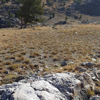


These glacial features are just thousands of years old, much younger than the volcanism. So what kind of rocks did these glaciers scour? A look at a hand sample reveals a very hard quartz sandstone—so hard it makes a ting sound rather than a thud when tickled with a rock hammer. Upon an even closer look with the hand lens, one can see the sand-sized, well-rounded, well-sorted grains of quartz, so well cemented together that when the rock breaks, it breaks across the sand grains instead of around them.
Technically, quartzite is a metamorphosed sandstone, but oftentimes this terminology is applied in the field to describe a quartz sandstone this hard. The "Geology of Elko" map published in 1987 does label Jack Peak as "gray quartzite" and gives their age as "Devonian, Ordovician, and Silurian age", or 485–358 million years old. These are OLD ROCKS!

This friend of the Owyhee standing among White Bark Pine looks up to the glacial headwall below Jack Peak and hummocky glacial terrain within the cirque. As we continued to hike, we soon identified a new rock type: chert. This black rock is made of microcrystalline quartz and deposited in the ocean as colloidal silica settles out of suspension as a "siliceous ooze". Because it has a chemical makeup similar to glass, it also breaks conchoidally into sharp pieces, or even knapped into sharp points.
From this vantage point, we could see the steep north-facing slope of the glacial headwall quite well. To my surprise, the gently dipping chert beds were clearly offset by a normal fault. A normal fault accommodates crustal extension. Kind of like a bookshelf with no bookend, the books extend away from one another and slide down, making little ridges and valleys. The Independence Mountains range, the range in which Jack Peak resides, is actually a normal fault-bound range much like the entire Basin and Range country of Nevada.
Then, another feature caught my attention. The horizontal beds of chert became truncated by another fault, putting chert against gray quartzite. AMAZING! A thrust fault! The older quartzite formation was thrust over the slightly younger chert formation, probably during the compressional mountain building (orogeny) episodes during the late Paleozoic to Mesozoic (250-180 million years ago). Based on the geographic location and rocks involved, the thrust fault may be an expression of the Sonoma Orogeny and the Golconda allochthon, though I need to do a lot more reading and research to pin that down.
As the group rested on the black chert in the saddle, I scampered up to the top of Jack Peak, passing over another fault and walking back onto gray quartzite. After a short yoga stretch, looking around, and taking pictures, I noticed my cell phone had signal. I texted my spouse, sent my son a goofy selfie from the peak, and sent a photo (panorama below) to the Friends of the Owyhee Board of Directors, Tim, and Katalin to share the joy (note: Katalin was at the Lower Owyhee Canyon for Public Lands Day coordinating a clean-up effort! Thanks to all that came out!). On the return hike down, I collected some chert samples to use in the Owyhee Rocks collection we use with our youth programming endeavors.


That evening, still needing more exploration, a couple of us drove to Tuscarora. It's a neat place that I look forward to going back to when the museum is open. Did you know there is a pottery school there?
But I still have one thing on my mind: the oldest rocks of the Owyhee watershed. To the east of the Independence Mountains, Nevada Highway 225 occupies the valley and connects Owyhee to Elko. That area is drained by the East Fork Owyhee, and the Wildhorse Reservoir collects those waters before it reaches Owyhee, NV. Months ago, while poring over maps of this region and looking for places to visit and rocks to touch, I noticed a dark brown swath of rock southeast of the reservoir as the river turns east. The color dark brown on geologic maps is reserved for Precambrian rock units—older than macroscopic fossilized life and than the Paleozoic rocks we had been hiking in. Sunday morning, we packed up, drove through Bull Run Basin on Maggie Summit Road (spectacular fall colors!!), and then south on Nevada Highway 225 toward the spot.
Now, I should clarify: this swath of brown is only present on one map and not two others. The Nevada Bureau of Mines and Geology (NBMG) has an interactive geologic map tool on their website that includes this swath. As our caravan turned onto gravel and I could see the low hills, my heart began to flutter. I'm pretty passionate about geology, as many of you know, and I find it a sacred endeavor to pilgrimage to rock sites such as this. I mean, the oldest rocks of the Owyhee are more than a billion years old!?!
We pulled up to the hill I had marked on my map, and oddly enough, there is a big turnout. Do geology classes come here to gawk at these rocks? Had the Geologic Society of America run field trips here? Did many other pilgrims stop here to be in the presence of such glory? Or maybe it is just a convenient pull-out. (In my mind, it could only be the former.)
Packs on, we charged up the hill toward a rock outcrop. From afar, I could already see fractures and textures in the rock that I was not expecting. With every step, my heart became heavier and heavier as I realized I was walking to a rhyolite outcrop. Hammer. Hand lens. Yep. Just rhyolite, the most common rock of the Owyhee. Fine-grained with a pinkish groundmass, large plagioclase phenocrysts homogeneously spread throughout, with a vitrophyre glass base. This unaltered lava rock is young. Head hanging, I hopelessly led the group to two more spots, already knowing the outcome: our search for the oldest rocks in the Owyhee—thought to be a Precambrian age schist (metamorphic rock)—was a farce. We were tricked. I think the map is wrong and will contact my friend at the NBMG to sort this out. Ideally, I'm wrong and Mike will laugh at me, telling me I just didn't walk far enough up the hill.


While parked, we scanned the rest of the landscape and our maps. By this point, my device had been used for pictures, music, and maps and had 2% battery left. I noticed a spring to the south labeled Owyhee River Source. "What? There is a source spring?" a friend proclaimed. And then, my device died. With no map to be confident we could make it there, we decided that was a trip for another day. Early next year, we will release the 2022 field trip list and I am determined to trip here with you friends of the Owyhee!


Sammy Castonguay is the Program Director for Friends of the Owyhee and was a founding board member back in the early days, helping Tim to expand reach, run more trips, and start youth programming. He is also a geologist, as if you didn't already know. :) In a few weeks, he will be presenting a poster at the Geologic Society of America conference (an all-vaccinated event, with a mandatory negative test 48 hours before arrival) in Portland, OR on Owyhee Geodiversity. The poster will reflect what I have observed in the Owyhee Geology Series and the content of the November 18th summary presentation.
This was the picture I sent to my son from the top of Jack Peak.